Wind parameters extraction from aircraft trajectories
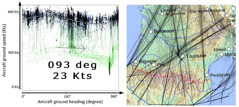
When supervising aircraft, air traffic controllers need to know the current wind magnitude and direction since they impact every flying vessel. The wind may accelerate or slow down an aircraft, depending on its relative direction to the wind. Considering several aircraft flying in the same geographical area, one can observe how the ground speed depends on the direction followed by the aircraft. If a sufficient amount of trajectory data is available, approximately sinusoidal shapes emerge when plotting the ground speeds. These patterns characterize the wind in the observed area. After visualizing this phenomenon on recorded radar data, we propose an analytical method based on a least squares approximation to retrieve the wind direction and magnitude from the trajectories of several aircraft flying in different directions. After some preliminary tests for which the use of the algorigthm is discussed, we propose an interactive procedure to extract the wind from trajectory data. In this procedure, a human operator selects appropriate subsets of radar data, performs automatic and/or manual curve fitting to extract the wind, and validates the resulting wind estimates. The operators can also assess the wind stability in time, and validate or invalidate their previous choices concerning the time interval used to filter the input data. The wind resulting from the least squares approximation is compared with two other sources – the wind data provided by Météo-France and the wind computed from on-board aircraft parameters – showing the good performance of our algorithm. The interactive procedure received positive feedback from air traffic controllers, which is reported in this paper.

Radar data (top view, right) from Toulouse Mode-S experimental radar, and “wind view” (left). In the wind view, records are in transparent black, and those of a same trajectory are connected by a colored line (low altitude records are in green , high altitude in blue).